Exceptional Athens Drought Case Study
Elijah Paciorek, Nico Sartori, Bailey Schaaf, Kaylee Sweeney, James Zinnbauer
Introduction
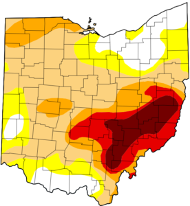
On August 27th, 2024, much of Athens County was upgraded to a D4 (Exceptional) drought, along with a large percentage of the surrounding Southeast Ohio region. This extraordinary classification, primarily driven by a significant rainfall deficit resulting from broader synoptic and global atmospheric conditions, marks the first time Athens County has reached D4 status since the U.S. Drought Monitor began in 2000. These conditions are expected to persist through fall and into the 2024-25 winter season. Using data from the USA Drought Monitor, NOAA, NCDC, and other climatological records, this case study aims to analyze the atmospheric patterns that led to the drought, assess the current situation in Southeast Ohio and adjacent locations, and explore the potential for continued drought conditions in the region.
Seasonal Synopsis
A. Definition
A drought is a prolonged period of insufficient precipitation, disrupting the hydrological cycle by creating imbalances in water storage, precipitation, evaporation, and runoff. This occurs due to atmospheric forcing and natural variability and can lead to significant agricultural and socioeconomic impacts. Drought indicators include reduced soil moisture, streamflow, groundwater levels, reservoir levels, and snowpack. Droughts can vary in duration, from short-term meteorological droughts, to 1–6-month agricultural droughts, to long-term hydrological and socioeconomic droughts lasting from one month to over two years (Wilhite, 2000). Athens is currently experiencing a long-term drought, marked by hydrological impacts on rivers and streams, and socio-economic challenges related to water availability.
B. Climatological Background
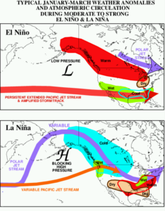
Fig. 1: El Niña (top) and La Niña impacts on the United States (CPC).
Natural variations in the atmosphere significantly influence global climate systems, including the atmosphere, ocean, land, and cryosphere, and are furthermore key drivers of droughts. One major source of variability in the United States is the El Niño Southern Oscillation (ENSO), which originates in the tropical Pacific Ocean. ENSO has two distinct phases: La Niña and El Niño. La Niña is marked by below-average sea surface temperatures in the Pacific, while El Niño features above-average temperatures. El Niño typically lasts 9–12 months, whereas La Niña can persist for 1–3 years. Both phases generally emerge between March and June, peak from December to April, and weaken from May to July.
Though ENSO does not directly cause individual natural disasters, it significantly impacts the jet stream and regions of high and low pressure, influencing storm intensity and track (CPC). For example, during El Niño, a persistent subtropical jet stream brings wetter and cooler conditions to the southern U.S., while warmer and drier conditions prevail in the northern U.S. In contrast, La Niña involves a variable subtropical jet and polar jet stream, leading to warmer and wetter conditions in the Midwest and drier, warmer conditions in the southern U.S. (CPC) indicated in Fig. 1. A transition from La Niña to El Niño was observed during the 2023 spring, peaking during the 2023-24 winter, then weakening during the 2024 spring. As of September 2024, ENSO-neutral conditions have persisted through the prior summer, with a 55% chance of La Niña developing by fall. While the dry conditions observed in 2023 (particularly during summer 2023) can be at least partially attributed to El Niño, other regional and local factors, including synoptic patterns, contributed a significant role in the drought observed through summer 2024 when ENSO-neutral conditions dominated the tropical Pacific Ocean.
C. Local Seasonal Precipitation and Temperature Summary
Across the contiguous United States, the meteorological summer of 2024 was 0.2℉ warmer than that of 2023, making it the fourth warmest summer in the National Centers for Environmental Information’s (NCEI) 130-year record. Additionally, August 2024 observed the third driest precipitation levels on record, with rainfall 0.16 inches below average . Much of southeastern Ohio and West Virginia experienced significantly below-average precipitation. Athens, which typically receives 39.58 inches of annual rainfall, experienced a precipitation deficit of 15.24 since 2023, and is well below normal so far through August 2024 (Fig. 2) —marking an unprecedented drought not seen since records began in the mid-1980s. However, it is important to note that a deficit of 22.95 inches was observed between 1995 and 2001, though only a D2 drought classification for Athens County, OH in 2002 resulted (Fig. 2 and 4, see appendix).
Examining the 2023-2024 monthly precipitation anomalies for Athens, both June-September in 2023 and 2024 experienced a sustained lack of precipitation, with 7.81 inches of deficit during Summer 2023, and 11.33 inches of deficit during Summer 2024. In addition, the February-March 2024 (Fig. 3) period further experienced a large deficit in precipitation compared to the average. Neighboring cities of Huntington and Parkersburg, West Virginia, have experienced comparable rainfall deficiencies. As observed from 2007-2008, Huntington endured a D3 drought (Fig. 7), with precipitation shortages totaling to 12.5 inches, and an even larger shortage of 20.22 inches of rainfall between 1999-2001 (Fig. 5). However, once again, due to a lack of a drought monitor prior to 2000, the severity of the drought in Huntington is still unclear. With an annual average of 43.13 inches of rainfall (usclimatedata), Huntington’s current deficit of 10.38 inches from the 2023 summer to now (Fig. 6) bears a comparable severity to the current Athens drought . Parkersburg furthermore experienced similar conditions, though to a lesser extent. Comparable to Huntington, a moderate to severe drought was present at the turn of the century, though a more sustained drought was observed between 2002-2003 (Fig. 10). A deficit of 7.36 inches of precipitation in 2016 contributed to another drought during that time, and deficits of 8.03 inches of precipitation from 2023 to the present have resulted in a similar severity of drought currently affecting Parkersburg (Fig. 9). Tangentially, a significant precipitation deficit was observed across all three locations between 1987 and 1988, with Athens recording a 16.98-inch shortfall, Huntington 16.68 inches, and Parkersburg 27.28 inches. These conditions suggest that a drought of similar severity to the 2023-24 event likely occurred in this region before –around 1988 – despite the absence of a formal drought classification at that time.
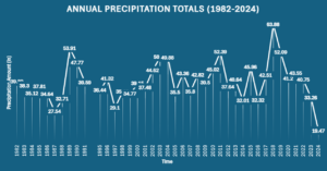
Fig. 2: Annual precipitation from 1982-2024 in Athens, Ohio (NCDC).
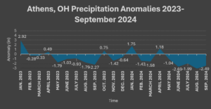
Fig. 3 : Precipitation anomalies in Athens, Ohio from 2023 through September 9, 2024.
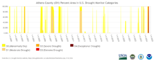
Fig. 4: Drought Monitor time series from 2000 to the present showing the severity of drought from D0-D4 in Athens County (USA Drought Monitor).
Current Conditions
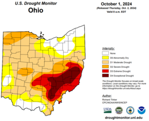
Fig. 11: Current drought monitor for Ohio (USA Drought Monitor).
From January 1st to October 1st, 2024, Athens has received 26.17 inches of precipitation, still largely undercutting the average of 39.58 inches of precipitation expected yearly (usclimatedata). Thus far, the 2024 year across the continuous United States has been the 10th driest year to date in the past 130 years. In particular, the summer season has been particularly dry, with barely an inch of rain recorded during the month of August, making it the 6th driest August on record in the past 130 years. As of October 1st, 2024, 58.93% of Athens County remains within a D4 drought (Fig. 11), and 0-100 cm soil moisture within the Athens area remains in the 5-15th percentile , indicating that the soil is roughly 85-95% drier than the climatological average (NIDIS). Much of the vegetation surrounding the Athens area remains in pre-drought to moderate drought stress, and crop moisture remains abnormally dry. However, brief relief was provided to the southeastern Ohio/West Virginia region as Post-Tropical Storm Helene entered the interior United States on September 28th, delivering 2.15 inches of rain between the 28th and 30th as the storm stalled over the southern Midwest and developed into a cutoff low. Even so, this rain was not enough to make significant drought improvement. The Hocking River, which prior to this event, remained at an incredibly shallow depth of 2.6 ft at the river gauge near the Stimson bridge, had risen to 3.27 ft. As of October 1st, the river has fallen to a depth of 2.9 ft (OHRFC). Streamflow currently remains below normal as well.
Future Outlook
Despite mild relief, consensus remains that near average temperatures and below average rainfall will persist for Southeast Ohio. Current 6–10-day outlooks published from the Climate Prediction Center suggest 40-50% chances of below average temperatures for the region alongside 50-60% chances below-normal precipitation. This pattern continues to persist through the 8-14-day outlooks (CPC). Through weeks 3-4 temperature and precipitation have equal chances of being above or below normal. Within a one-month outlook, temperatures will continue to experience equal chances of experiencing above or below normal conditions and precipitation is leaning below normal with a 33-44% chance; it isn’t until the winter that there’s more of a chance of increased precipitation in northern Ohio especially (CPC).
These forecasted patterns support the claim that drought conditions are likely to persist in both the short-term and long-term for Southeast Ohio. In addition, the U.S. Seasonal Drought Outlook by the Climate Prediction Center has reported drought conditions to continue through the valid period of October 1st – December 31st, 2024, reported on September 30th, 2024, indicated in Fig. 12 (CPC).
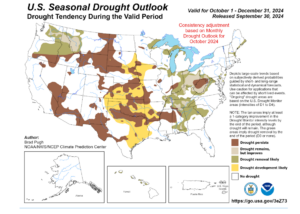
Fig. 12: Seasonal drought outlook through the end of December 2024, released on September 30th, 2024. Drought is likely to persist for much of Southeast Ohio and parts of West Virginia (CPC).
Conclusion
The 2023–2024 drought in Athens County and surrounding Southeast Ohio/West Virginia region has been historically severe, marked by substantial rainfall deficits and exceptional drought status. The analysis of atmospheric drivers, particularly ENSO’s influence, underscores the complexity of factors contributing to the drought. While El Niño exerted notable influence in creating nationally drier conditions, local and regional synoptic patterns over the last two years have exacerbated the situation, creating a drought of such severity only comparable only to one of roughly 36 years ago (near 1988) within our currently climatological record.
With precipitation deficits exceeding 16 inches for two consecutive years and soil moisture levels in incredibly low percentiles, the region continues to face significant agricultural and ecological impacts. Though brief relief came from Post-Tropical Storm Helene, forecasts indicate a continuation of below-average precipitation, suggesting drought conditions will persist into the winter months, compounding ongoing local challenges in the area. Moving forward, the continued monitoring of climatic trends and regional impacts will be crucial for understanding the full extent of this ongoing drought and for preparing adaptive strategies to mitigate further consequences.
References
Community collaborative rain, hail & snow network. (n.d.). CoCoRaHS. https://www.cocorahs.org/Stations/ListStations.aspx. Accessed 3 October 2024
Data. (n.d.). Data | U.S. Drought Monitor. https://droughtmonitor.unl.edu/Data.aspx. Accessed 3 October 2024
National Water Prediction Service. (n.d.). NOAA. https://water.noaa.gov/. Accessed 3 October 2024
NCEI Asheville Hurricane Helene outage. (2024, October 2). National Centers for Environmental Information (NCEI). https://www.ncei.noaa.gov/node/6696. Accessed 3 October 2024
Parkersburg, WV Weather historystar_ratehome. (n.d.). Weather Underground. https://www.wunderground.com/history/monthly/KPKB/date/1980-9. Accessed 3 October 2024
Soil moisture. (n.d.). Drought.gov. https://www.drought.gov/topics/soil-moisture. Accessed 3 October 2024
Weather averages Athens, Ohio. (n.d.). Temperature – Precipitation – Sunshine – Snowfall. https://www.usclimatedata.com/climate/athens/ohio/united-states/usoh0037. Accessed 3 October 2024
Webmaster, C. (2001, January 1). NOAA’s Climate Prediction Center. Climate Prediction Center. https://www.cpc.ncep.noaa.gov/. Accessed 3 October 2024
Appendix
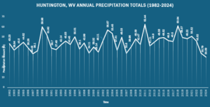
Fig. 5: Annual Precipitation totals in Huntington, West Virginia from 1982-2014 (NCDC).
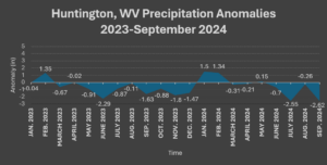
Fig. 6: Precipitation Anomalies in Huntington, West Virginia from 2023 to September 8, 2024 (NCDC).
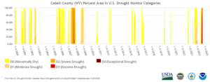
Fig. 7: Drought monitor time series from 2000 to present showing the severity of drought from D0-D4 in Cabell County (USA Drought Monitor).
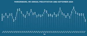
Fig. 8: Annual precipitation totals in Parkersburg, West Virginia from 1982 through September of 2024 (NCDC).
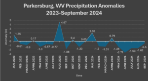
Fig. 9: Precipitation anomalies in Parkersburg, West Virginia from 2023 through September 9, 2024.
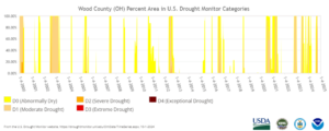
Fig. 10: Drought monitor time series from 2000 to present of drought severity from D0-D4 in Wood County (USA Drought Monitor).

