
August 12, 2023 Athens County Tornado Case Study
Cameron Cousino, Nico Sartori, Ashlee Ziegler, James Zinnbauer

Figure 1: Observed tornado taken at 2333Z on August 12th, 2023 by James Zinnbauer, from River’s Edge, Ohio University
Introduction
On August 12th, 2023, a slight risk of severe thunderstorms had been issued by the Storm Prediction Center (SPC) at 1200Z, which had encompassed most of Ohio, with an additional enhanced risk from Pennsylvania reaching into Northeastern Ohio. For Southeastern Ohio, a 2% risk of tornadoes was issued, and by 2254Z, a supercell exhibiting weak rotation approached Athens, Ohio. This cell was the only supercell that had developed in southeastern Ohio, and despite an improbable synoptic and mesoscale setup, a tornado was reported at 2333Z, beginning in Angel Ridge Road. The tornado was designated an EF-1, and had tracked 2.3 miles across Athens County, with wind speeds at 100 mph. This tornado was one of seven tornadoes ever recorded in Athens County and was only a few miles away from Ohio University. This case study will detail the atmospheric setup for this severe event and the forecasts issued, and a verification of the resulting storm.
Synoptic Overview
A weak upper-level trough in the atmosphere moved through the Ohio Valley placing the right exit region of the jet streak, an upper-atmospheric region of more intense winds over southeast Ohio (figure 1). This “right exit” region is typically less favorable for supercellular development and will usually favor surface high pressure and downward motion; which would prevent any meaningful vertical development of thunderstorms. Vertical motion is a necessity in the development of severe thunderstorms, and the formation of a supercell in these synoptic conditions is unusual while the synoptic-scale vertical motion is downward, which will generally warm air parcels and prevent the deep condensation required for severe thunderstorms.
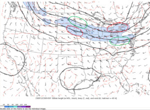
Figure 2: A typical “four quadrant” analysis of the event’s jet streak, with red areas being more favorable for severe development, and green areas being less favorable.
At the surface, a low-pressure system moved over the Great Lakes to the north with an associated cold front. The cold, denser air mass then cut through warmer air, causing the less dense warm air to rise, providing an adequate lifting mechanism for the warmer air to be condensed, assuming there is enough moisture. In this case, surface dewpoints were in the low-70s which is enough moisture to support storm development.
Mesoscale Overview
Despite an unfavorable synoptic setup, the SPC had caught onto some of the small-scale features that could result in this unlikely tornadic event. Their 1537Z discussion noted bulk wind shear values between 30 and 40 knots, and storm relative helicity (SRH) values in excess of 100 m2/s2. These parameters characterizing the wind field will facilitate both longer lived supercell storms and support a cyclonically rotating updraft within these storms, respectively. These are both important for tornado development and when combined with high values of convective available potential energy (CAPE), will allow strong thunderstorms to rapidly develop. Given adequate forcing, such as the aforementioned cold front, an environment with around 1,500 J/kg could sustain long-track severe thunderstorms. Numerical weather prediction (NWP) models suggested the CAPE on August 12th could be as high as 4,000 J/kg, which was evidence of an extremely volatile atmosphere which allowed for a strong severe weather event despite an unfavorable synoptic pattern.
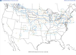
Figure 3: The 0-6 km bulk shear map shows Athens County with values between 30-40 kts (Storm Prediction Center).
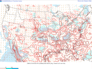
Figure 4: The SBCAPE map shows Athens County within the 3000 J/kg contour. (Storm Prediction Center)
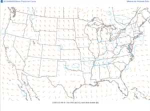
Figure 5: The 0-1 km SRH map shows Athens County between 50-100 m2/s2 SRH values. (Storm Prediction Center)
In cases where storms have an inordinate amount of CAPE, forecasters can be concerned about dry-air entrainment in the development of the storm, where dry air from outside the storm is mixed in with the updraft. In scenarios like this one, with CAPE values disproportionately higher than wind shear, the storm’s updraft will be narrower and drier. This will result in a low-precipitation (LP) supercell, which is highly visible but not normally conducive for tornadoes. Due to the storm’s precipitation inefficiency, there is a lack of any of the typical downdrafts expected in supercell, which both decreases the chance that an LP storm will be tornadic and gives it a different appearance on radar, presenting in a more triangular fashion and missing the usual “hook” that commonly denotes a tornado on radar.
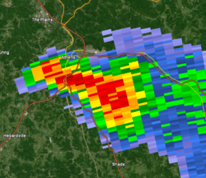
Figure 6: Radar image at 7:25pm of the LP Supercell southwest of Athens, OH. Note the more triangular shape.
Discussion
Satellite imagery from 1600Z revealed an expansive field of bubbling cumulus clouds along the cold front. Ahead of the front was a heating zone, which, along with southwest winds and cool mid-level temperatures, would promote storm development along the line in hours. A supercelluar storm mode was favored initially, with more line segments forecasted to develop over time. Estimated SRH values for the region around 100 m^2/s^2 would provide adequate rotation for any of these storms developing along the cold front, so Southeast Ohio was being monitored closely for tornado development. At 2000 Z, another mesoscale discussion was issued by the SPC, currently reporting widely scattered supercells from eastern Ohio into northern Pennsylvania, and this pattern was likely to continue for the next several hours as the cold front moved further southeast. Deep-layer shear still promoted supercelluar development along this front.
By 2000Z, the preliminary stages of storm development were observed via satellite occurring in Southeast Ohio. The most rapidly developing of these began entering the western portion of Athens County at 2300Z and was exhibiting weak rotation, but about 20 minutes later, the cell’s radar signature became less impressive. At 2323Z, the cell underwent a period of reintensification as it passed south-southeast of Athens, Ohio. It began exhibiting much stronger reflectivity, and showcased a more pronounced velocity couplet, indicating more pronounced rotation in the storm. This intensification begot a funnel cloud, which was visible from the ground, and a tornado that was observed at approximately 2334Z on Angel Ridge Road. A tornado warning was soon prompted by NWS Charleston. The tornado was observed on the ground for about 10 minutes, having been seen dissipating at 2343Z past Kincade Road.
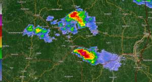
Figure 7: Radar reflectivity scan at 2334Z on August 12th, 2023, approximately when the tornado was observed.
A tornado warning continued to be in place for southeastern Athens County into 2358Z, which was also extended into southwestern Washington County. As the cell crossed into West Virginia, a severe thunderstorm warning was issued at 0017Z on the following day. Convection north of the cell around this time began to develop more strongly, congealing more with the supercell, before the last tornado warning had expired by 0045Z, as the storm weakened through northeastern West Virginia.
The storms following this front merged more into a quasi-linear convective system, most known as a squall line, and another mesoscale discussion was issued by the SPC at 0112Z on August 13th, reporting on the still strong-to-severe cluster of storms tracking through Southern Pennsylvania and northern West Virginia. Due to the nature of the linear system, severe wind gusts now became the primary threat, and eventually the storms dissipated as the night and the Appalachian Mountains stabilized conditions in this area.
Conclusion
This tornado was a climatological rarity for Southeast Ohio, especially considering the synoptic conditions for the storm. This is the seventh documented tornado in Athens County, and the first tornado since 2018, as reported by the National Weather Service. Athens County is topographically challenging for sustaining long-track severe storms, since mountainous terrain can quickly disrupt the updraft of severe storms, which is the reason for this apparent lack of tornadoes.
The ample wind shear was suspected to be the cause for the cell’s sustained rotation and eventual tightening, it is likely an area of moisture tapped into southeast of Ohio University’s campus as the cell travelled past the Hocking River, promoting the cell’s reintensification after initial weakening as it grazed Athens, OH. Also noted was the low lifted condensation level observed within the mesocyclone of the storm, which is unusual for a low-precipitation supercell such as this. This would also be a contributor in reaching the conditions necessary to spawn a tornado, and why such an unlikely setup yielded a tornado in the first place. This can be observed within Figure 1, as shown by the cloud base in the mesocyclone above the tornado.
From this event, 12 tornadoes were reported in Ohio, Pennsylvania, New York, and Massachusetts, alongside several hundred wind reports across the country. Notably, the tornado in Athens County was the furthest southwest reported tornado from the day. The National Weather Service’s storm survey reports “An EF-1 tornado with maximum winds up to 100 mph touched down near Angel Ridge Road in Athens County. The tornado tracked east-northeast, crossing Gura Road, Long Run Road, North Coolville Ridge Road, before lifting just past Kincade Road. Damage was limited to snapped and uprooted trees and some snapped power poles along the path with the worst damage occurring in a 300-yard-wide swath along Long Run Road.”
Additionally, this tornado received a tornado warning 2 minutes after the funnel was observed from the ground, which is typically poor lead time for a tornado warning. This lack of a quick warning for this event was almost certainly due to a lack of comprehensive radar coverage in Southeast Ohio. The closest fully operational radar station is over 70 miles from the tornado site. Since radar beams need to be emitted at an angle, and the beam needed to cover a significant amount of ground, the observations from NWS Charleston’s radar were taken at over 6,000km in the air. Due to the beam’s lofty height, it is likely that the radar’s observations were not truly representative of the storm. Closer to the surface, the storm would have exhibited a much more defined velocity couplet, and it would have been apparent earlier, which would have allowed the NWS to warn the storm in a much timelier fashion.
The Athens County tornado of August 12th, 2023 was certainly an interesting exploration into the importance of mesoscale and microscale forecasting in a severe weather event, and how even in both unfavorable synoptic atmospheric conditions and adverse topography tornadic events can still occur. There are a multitude of lessons forecasters can take from this event, and our understanding of tornado development in Athens County will hopefully be able to be applied to future severe weather events in the greater Appalachian area.