
In events of anomalous weather localized in the Southeast Ohio region, Scalia Laboratory will produce an in-depth case study detailing the atmospheric setup, timeline, and resulting impacts. For broader reports of larger-scale yet still notable events, click here to read Scalia Laboratory’s Reports.
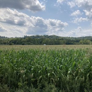
August 2025: Driest August Ever Recorded for Athens County
Click here to read the full article:
Courtesy of Gabriel Scotto, Athens Messenger
Athens is no stranger to dry weather in the late summer and fall seasons. Last year, the county experienced exceptional drought conditions that brought significant agricultural and ecological impacts to the region. Luckily, this year has not been as dry as last year’s drought. However, there was one notable record broken: August 2025 was the driest August month on record for Athens County. Using data from the Scalia Laboratory weather tower, CoCoRaHS Data Explorer, USA Drought Monitor, and the Climate Prediction Center, this article breaks down how this year’s August compares to other years historically and explains how conditions remained so dry throughout the month.
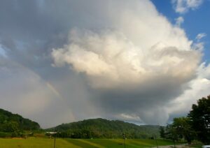
January 5-6 Winter Storm
Click here to read the full case study:

Courtesy of Ohio University
On January 3rd, 2025, a low pressure developed leeside of the Rocky Mountains, progressing eastward and developing into a potent winter storm. By January 5th, the system arrived in the Midwest region, delivering heavy winter precipitation in narrow corridors sharply divided by small variations in vertical temperature. Snowfall accumulations reached 6–12 inches in southern Ohio, while significant ice accumulation from freezing rain and sleet impacted Kentucky, Tennessee, and West Virginia. Widespread power outages and hazardous travel conditions ensued across Southeast Ohio. Using data from the WPC, NWS, and IEM, this case study aims to analyze the atmospheric setup contributing to the lifecycle of the low-pressure system, along with the regional and local impacts resulting from its arrival.
Exceptional Athens Drought
Click here to read the full case study:
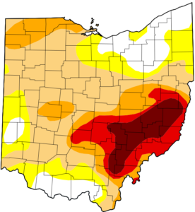
U.S. Drought Monitor drought severity map for Ohio
On August 27th, 2024, much of Athens County was upgraded to a D4 (Exceptional) drought, along with a large percentage of the surrounding Southeast Ohio region. This extraordinary classification, primarily driven by a significant rainfall deficit resulting from broader synoptic and global atmospheric conditions, marks the first time Athens County has reached D4 status since the U.S. Drought Monitor began in 2000. These conditions are expected to persist through fall and into the 2024-25 winter season. Using data from the USA Drought Monitor, NOAA, NCDC, and other climatological records, this case study aims to analyze the atmospheric patterns that led to the drought, assess the current situation in Southeast Ohio and adjacent locations, and explore the potential for continued drought conditions in the region.
August 12th, 2023 Athens County Tornado
Click here to read the full case study:
Photograph by James Zinnbauer, 8/12/23
On August 12th, 2023, a slight risk of severe thunderstorms had been issued by the Storm Prediction Center (SPC) at 1200Z, which had encompassed most of Ohio, with an additional enhanced risk from Pennsylvania reaching into Northeastern Ohio. For Southeastern Ohio, a 2% risk of tornadoes was issued, and by 2254Z, a supercell exhibiting weak rotation approached Athens, Ohio. This cell was the only supercell that had developed in southeastern Ohio, and despite an improbable synoptic and mesoscale setup, a tornado was reported at 2333Z, beginning in Angel Ridge Road. The tornado was designated an EF-1, and had tracked 2.3 miles across Athens County, with wind speeds at 100 mph. This tornado was one of seven tornadoes ever recorded in Athens County and was only a few miles away from Ohio University. This case study will detail the atmospheric setup for this severe event and the forecasts issued, and a verification of the resulting storm.

