
2024 Year In Review
Elijah Paciorek, Nico Sartori, Bailey Schaaf, Kaylee Sweeney, James Zinnbauer
Introduction
The year 2024 unfolded as a dynamic and volatile period for global weather and climate, marked by record-breaking heat, anomalous storm activity, and notable regional anomalies. Persistent oceanic warming, shifting atmospheric patterns, and a neutral ENSO phase all contributed to an array of extreme events, ranging from catastrophic hurricanes in the Atlantic to prolonged droughts and heatwaves across multiple continents. On a continental scale, North America grappled with contrasting hazards, from severe winter storms in the Midwest to large and damaging wildfires in the Southwest. Locally, Ohio experienced their share of weather extremes, including a record total of reported tornadoes and a catastrophic drought. This report aims to discuss the significant weather and climate anomalies observed throughout 2024, exploring their underlying causes and regional consequences.
Global
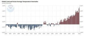
Figure 1. Global Land and Ocean Temperature Anomalies from 1850 to 2024 (NOAA).
The global land and ocean average temperature anomalies were the warmest anomalies on record, reaching roughly 1.3°C and breaking the 2023 record of roughly 1.2°C (Fig. 1, 2). When comparing annual global average temperatures to the 1850-1900 pre-industrial period, 2024 was the first year since records began to exceed 1.5°C of warming. North America, Europe, Africa, and Oceania all recorded their warmest years on record, with North America and Africa surpassing the records set in 2023. South America tied its 2023 record for the warmest year, while Asia and Australia experienced their second warmest years on record. Furthermore, the global ocean surface temperatures were the warmest on record from April 2023 to June 2024, and the yearly 2024 average 0-2000 m global ocean heat content surpassed 30 x 10^22 J (Fig. 3). As a result, the Arctic had the seventh smallest minimum sea ice extent on record in addition to its second warmest year on record. The Antarctic sea ice extent was the second lowest on record at its maximum and tied with 2022 for the second lowest on record at its minimum.
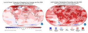
Figure 2. Land and Ocean Temperature Departures (left) and Land and Ocean Temperature Percentiles (right).
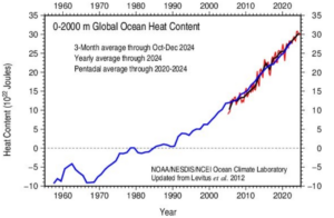
Figure 3. 0-2000 m Global Heat Content. The three lines displayed are the 3-month average through Oct-Dec 2024, the yearly average through 2024, and the pentadal average through 2020-2024.
Anomalous weather events also marked the 2024 year. Globally, tropical cyclone activity was slightly below average, with 85 named storms, 42 of which reached hurricane, typhoon, or cyclone strength. The Atlantic stood out with above-average activity, recording 18 storms and 11 hurricanes, including Hurricane Beryl and Hurricane Helene. Click here to read Scalia Laboratory’s 2024 Atlantic Hurricane Season Report. In contrast, the Eastern North Pacific, South Indian, and Western North Pacific basins all experienced below-average seasons, while the North Indian Ocean saw just 4 storms. Meanwhile, the Western North Pacific produced 23 storms, with Typhoon Yagi peaking at Category 4 strength and becoming one of the strongest typhoons to strike Northern Vietnam and Southern China, causing widespread damage and hundreds of fatalities.
Beyond tropical systems, other extreme weather events left significant impacts worldwide. Southern Spain experienced devastating flooding in late October, with historic rainfall leading to catastrophic destruction and over 200 deaths in the Valencia region. In April, the Persian Gulf region recorded two years’ worth of rainfall within 24 hours, causing major disruptions and more than 20 fatalities across the UAE and Oman. Severe drought gripped large parts of South America, fueled by record and near-record heat across the continent.
National
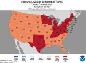
Figure 4. Temperature Ranks for the Contiguous United States.
The United States experienced a range of extreme weather events in 2024. Climatologically, it was the warmest year on record for the nation (Fig. 4), with an average temperature of 55.5°F, 3.5°F above the long-term average. Despite the heat, 2024 ranked as the third-wettest year on record due to heavy localized precipitation events, including significant snowfall in Alaska, torrential rains from a low-pressure system in Hawaii, and landfalling hurricanes. Drought conditions fluctuated throughout the year, with coverage ranging from a low of 12% in June to a peak of 54% by late October (Fig. 5). Severe weather also left its mark, with six separate tornado outbreaks across the central and southeastern U.S., each resulting in billion-dollar damages. The Atlantic hurricane season was notably active, with 18 named storms and five hurricanes making landfall, reinforcing the year’s above-average tropical activity. Wildfires also brought widespread destruction, with California’s Park Fire burning nearly 430,000 acres — the fourth-largest wildfire in state history — and destroying over 600 structures. In Texas, the Smokehouse Creek fire in the Panhandle scorched over 1 million acres from February to March, ranking among the largest wildfires in Texas history.
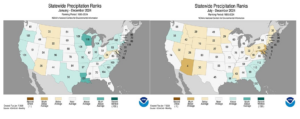
Figure 5. Precipitation Ranks for the Contiguous United States. January through December (left) is contrasted with July through December (right).
State
Ohio experienced above-average temperatures throughout 2024, aligning with national trends. Precipitation patterns were more varied, with approximately 34.1% of Ohio’s counties — primarily in southeastern and central regions — experiencing dry or near-record dry conditions, largely due to the significant fall drought (Fig. 6). Some of these areas continued to face drought conditions into the new year. In contrast, southwestern and northern Ohio saw wetter-than-average conditions. Regarding severe weather, Ohio recorded 74 tornadoes in 2024 — breaking the previous record of 62. Among these was a devastating EF-3 tornado that struck Indian Lake on March 14, tragically claiming three lives and injuring many more. The tornado’s path through a trailer park community left residents particularly vulnerable. Additional tornado outbreaks impacted Ohio on May 7, striking southwestern areas, and on August 6, when storms produced tornadoes along Lake Erie. The latter event left many homes without power, adding to the challenges faced by affected communities.
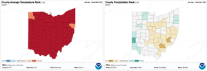
Figure 6. Temperature and Precipitation ranks for Ohio counties (NOAA).
Amid the year’s many weather disasters, Ohio also witnessed rare and awe-inspiring astronomical events. A total solar eclipse crossed over half of Ohio on April 8, 2024, and major cities in the path of totality included Columbus, Dayton, Cleveland, and Toledo. Although only parts of the state experienced full totality, the eclipse was visible statewide, captivating Ohioans with this once-in-a-generation event. Ohio furthermore witnessed two major geomagnetic storms in 2024, allowing residents from northern to southern parts of the state to observe the Aurora Borealis. The stunning displays of the northern lights made for an extraordinary atmospheric event.
Local
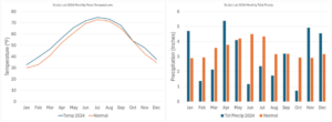
Figure 7. Athens annual temperature and precipitation compared to the climatological average taken from observations from the Scalia Laboratory of Atmospheric Analysis.
Temperatures in Athens, Ohio, remained 1-2 degrees Fahrenheit above average, excluding the near-average temperatures in September and October. Despite this record, precipitation remained the most critical anomaly in 2024 for the region (Fig. 7). Athens received roughly 33 inches of precipitation, which is 7 inches below normal, and following a below average year in precipitation the previous year. 2024 was of the driest years in Athens on record (Fig. 8), with the 1930 Dust Bowl holding the current record, though with a comparable magnitude to the 2024 drought (NOAA). Despite a wet start to the year, with January and April exceeding the average monthly rainfall, strong atmospheric ridging patterns promoted long-standing high pressure across much of the eastern United States, resulting in exceptional precipitation deficits during the growing season of June through October. Precipitation deficits were alleviated during November and December. However, these provided little relief, as above average monthly precipitation was reached from a few significant flooding events rather than sustained rainfall throughout the month.
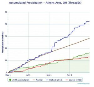
Figure 8. Accumulated precipitation in the Athens area in 2024 (green) compared to the highest in 2018 (in blue), lowest in 1930 (red), and the normal (brown) (ThreadEx).
According to the Palmer Drought Severity Index (PDSI), the end of 2024 saw an index of below -4.0, meeting criteria for exceptional drought conditions. The USA Drought Monitor subsequently issued a D4 drought for much of the state during the Fall season (NOAA; USA Drought Monitor). With a PDSI of -7.00 in 1930 and -6.00 in the mid-50s, 2024 was one of the warmest and driest years on record in Athens in the context of the 20th century. Relief from the drought occurred with above-average precipitation during the start of 2025, with over 5 inches of precipitation recorded during February. Currently, a drought is not present in Athens, but the long-term impacts of drought are still being felt across the area (USA Drought Monitor).
Conclusion
The year 2024 was a year of profound climate and weather extremes, with significant global, national, state, and local impacts. Globally, the unprecedented warmth and record-breaking ocean temperatures, combined with destructive storms and severe droughts, demonstrated the ongoing intensification of climate-related phenomena. The United States saw an amplified range of weather events, from catastrophic wildfires to powerful hurricanes, while Ohio’s localized weather patterns reflected both the broader national trends and specific regional anomalies, including a historic drought and an exceptional tornado season. At the local level in Athens, Ohio, the persistent dry conditions and severe precipitation deficits in 2024 underscored the vulnerability of certain regions to prolonged drought, despite pyrrhic relief from localized rainfall events later in the year.
Throughout 2025, the long-term consequences of these extreme weather events, particularly the drought and its impact on agriculture and water resources, will require ongoing attention and adaptation. 2024 has underscored the urgent need for continued research into the drivers of these extreme weather patterns, as well as the development of mitigation and resilience strategies to better prepare for similar events in the future. The persistence of rising global temperatures and the subsequent anomalous weather activity has demonstrated that the ongoing climate crisis will remain a dire imposition to human life worldwide.